Perched on a wooded, sunny plateau above the Rhône Valley about halfway between Martigny and the Chateau de Chillon end of Lake Geneva, Villars offers activities that find the balance between recreation and relaxation.
Ever since the famous Orient Express arrived here, visitors to Villars have enjoyed the healthy air to be found on the natural balcony it rests on. At about 1,300 meters (4,225 feet) in the heart of the Vaud Alps, this idyllic setting has stunning views stretching from Lake Geneva to Mont Blanc.
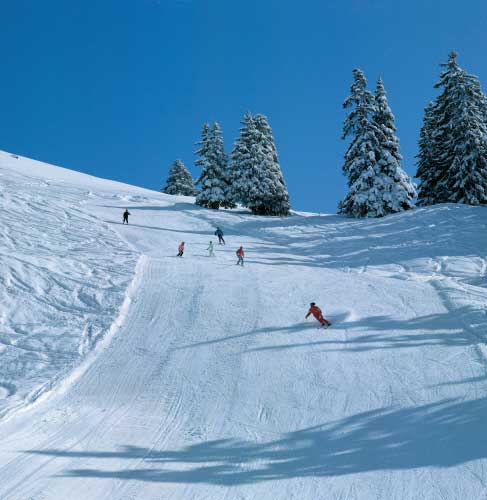
Winter sports fans can enjoy the wide range of attractions the area offers, including 125 kilometers (78 miles) of skiing terrain. In all, there are 52 runs which are 50 percent beginner, 42 percent intermediate and eight percent advanced. Sports enthusiasts wanting to be challenged can try the glacier at Les Diablerets, about 20 kilometers (13 miles) from Villars. There are four glaciers in the area available for heliskiing.
Those in search of relaxation can enjoy the facilities and wellness benefits of the thermal baths (Lavey-les-Bains). Children can enjoy the family programs that cater to adults and kids.
Consists of 870 miles of trails from soaring cliffs to golden sands
Photos courtesy Visit Britain
The Wales Coast Path creates a complete path along the whole Welsh coastline, and together with the Offa’s Dyke Path, the total route extends to more than 1,000 miles. The Coast Path winds its way through towns and villages, across cliff tops and sandy beaches, sometimes darting inland before emerging at a sheltered cove or tiny hamlet that you would forever miss when traveling by car, bus or train.
The Wales Coast Path has been developed by the Welsh Government in partnership with the Countryside Council for Wales, 16 local authorities and two national parks. In addition to funding from the Welsh Government and the coastal local authorities of approximately $3.15 million per year, the European Regional Development Fund has allocated $6.29 million over four years in support of the project.
Improvements to the quality and alignment of the route will continue during 2012 and 2013 to ensure that the path follows the Welsh coastline as close as it is safe and practical. Over time, the Wales Coast Path is expected to lead to the creation of circular coastal routes as links to inland towns and villages are improved.
Wales is a country blessed with a beautiful coast and stunning scenery. The Wales Coast Path will ensure improved access to the coastline and encourage people to live a healthier and more active lifestyle.
SHAPE OF THE NATION
In the northeast, on the border between Wales and England, the path sets off near Offa’s Dyke, near the coastal town of Prestatyn on the shores of the Irish Sea. This historic dyke is named after the 8th century King Offa, who ordered the dyke be built to separate his kingdom of Mercia from rival kingdoms in what is now Wales. This 177-mile path, forming one of Wales’ three national trails, runs along the Anglo-Wales borderlands. With the development of the coastal path, this will enable visitors to walk around the whole of Wales.
This historical journey continues as the path winds through nearby Conwy with its impressive 13th century castle built by Edward I. The coastal path passes a number of other medieval castles along its way such as Caernarfon, Beaumaris, Criccieth and Harlech in the north, Aberystwyth in mid Wales, and Cardiff and Caldicot in the south. It passes by ancient churches such as St. Hywyn’s in Aberdaron on the Lleyn Peninsula, where since medieval times, pilgrims have come on their way to Bardsey Island, the legendary Isle of 20,000 saints.
All along the coastal path there is breathtaking scenery; places such as Anglesey in the north and Pembrokeshire in the south are especially beautiful. In western Wales, a half mile section of the path recently opened joins the Ceredigion Coast Path with the Pembrokeshire Coast Path National Trail creating a 250-mile unbroken path. Last year, National Geographic voted Pembrokeshire “one of the best coastal destinations in the world, a wonderful part of Wales that must be seen and explored.” There are a variety of beaches along the way, ranging from expansive stretches of sand to tiny sheltered coves.
The wildlife that can be seen while exploring Wales’ coastal path is rich and diverse. Exploration of the coastline along the path reveals bays, headlands, towering cliffs and inlets, all provide stunning views of nesting seabirds, guillemots, razorbills, puffins and shearwaters. Out to sea off the Ceredigion Coast in Cardigan Bay, bottlenose dolphins and porpoises can be seen playing in the surf, and its sheltered inlets and coves harbor Atlantic grey seals basking on the beach or bobbing up and down in the sea.
Wales is famous for its seaside resorts. Among others, the path passes through Tenby in the Southwest, a town steeped in history, renowned as being one of Britain’s finest holiday resorts, and in the north, Llandudno, Wales’ largest resort, a town that has kept its Victorian and Edwardian splendor and boasts two great beaches.
Situated along the coastal path are some of Wales’ finest inns such as the Ty Coch Inn nestled in the tiny fishing village of Porthdinllaen on the north coast of the Lleyn Peninsula, with views across the Irish Sea and with a sandy beach on its doorstep, boasting a fine selection of food and ales.
The number of walkers along the coast is increasing continually, but the path is also suitable for cyclists and horseriding on large stretches and also invites the disabled along its length.
Vilnius, capitol of Lithuania, is not only famous for its old town, which is included in the UNESCO World Heritage list, but also for all its greenery. This city can definitely also be called a cyclist’s dream.
Start the route around the old town from Cathedral Square, considered to be the very heart of Vilnius. Visit the snow-white Cathedral of Vilnius.
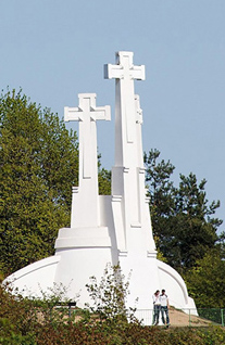
Hill of Three Crosses
From the square you can see Gediminas Hill with its 15th century tower of the Upper Castle and the Hill of Three Crosses. Climb these hills and enjoy an amazing view of the old town.
The cycle path from Cathedral Square leads to Pilies Street, the oldest and the most gorgeous street in the entire city. Pilies Street widens into Didžioji Street, at the end of which stands the white Vilnius Town Hall.
Here you can turn right into Vokiečių Street. Cross over Traku Street to Vilnius Street, which brings you to Gediminas Avenue, the main street of the capital. Turn right and here you are again, standing in front of the cathedral.
Cross the Neris River on the Mindaugas Bridge and you arrive at a section of the cycle path, where you will forget you are in a city. Feel the greenness and quietness surrounding you. All the way around the Neris River is on the right.
Starting at the Santariškės traffic ring, a 3-mile-long asphalt cycle path has been built. It goes along Green Lakes, crosses Verkiai forest, and finally ends at the intersection with Gulbineliai Street.
While on this path don’t miss the architectural complex of Verkiai Palace, built 200 years ago. In ancient times, there was a pagan temple here. Behind the palace, on a cliff, is an observation platform, from which a view of the Neris Valley opens up.
Take forest roads from Verkiai Palace and you arrive at Ežerėliai Geomorphologic Reserve. At the top of the hill you will see Alsas Lake. Go down to Gulbinai Street which leads towards Balsys Lake and cross the small linden forest and finally you arrive at Balsys Lake, where swimming on a hot summer day is refreshing.
If you prefer not to travel alone, you can always join cycling trips around Verkiai Regional Park, organized by the Pavilnys and Verkiai Regional Parks administration. During the warm season you can travel the route Verkiai Palace – Ežerėliai – Green Lakes – Riešė and Turniškėlė – Verkiai Palace.